


 Nepal’s Glacial Debris Flow Could Be Among Most Severe in Decades, WMO Expert Says
(Yicai) Sept. 7 -- The Nepal incident is likely among the most severe events of its kind in recent decades, given the speed at which it occurred, the extensive destruction, and the compounding cross-border impacts, Narelle van der Wel, head of cryosphere monitoring, predictions, and services at the World Meteorological Organization, told Yicai.
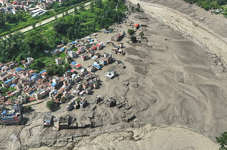
On Aug. 26, an ice-rock avalanche originating from a high-altitude area in the Himalayas tore through the China-Nepal border, destroying towns, roads, and bridges, causing 1,385 deaths and leaving more than 5,500 missing, based on official data as of yesterday.
Preliminary WMO assessment based on video footage and information from affected areas suggests that a large volume of ice and rock debris entered the Lende Khola, a tributary of the Bhote Koshi River, causing the flash flood.
The disaster comes amid a broader trend of accelerating glacier loss driven by global warming. Mountain glaciers worldwide have lost about 958.3 billion metric tons of ice since 1975, with nearly 80 percent of that loss occurring after the year 2000, according to data from the World Glacier Monitoring Service.
Excerpts from the interview with van der Wel are below:
Yicai: Would you say that the debris-flow disaster that struck Nepal is the most severe disaster of its kind over the past decade? How do you assess the cause?
Van der Wel: It isn't currently possible to determine this, as impacts are still occurring and being verified. However, the speed at which it occurred, the extensive destruction, and the compounding cross-border impacts indicate that it is likely among the most severe events of its kind in recent decades.
Initial analysis of satellite imagery suggests this may have been a combined rock-and-ice slope failure, possibly initiated by the failure of the underlying bedrock, rather than simply a glacier collapse. The initial failure appears to have entrained additional ice, rock, and sediment before transforming into a destructive debris flow and flood. We will need to wait to know for sure what the cause was.
“Most severe” also depends on whether the measure is loss of life, people displaced, physical scale, or economic disruption. In this case, damage to a major cross-border trade route, transport links, and other infrastructure will contribute substantially to the overall impact, but the economic losses cannot yet be reliably quantified. If measured by loss of human life, preliminary reports suggest that [the death toll from] the current event may exceed the 2015 Langtang event, identified as the most destructive of the 60 events analyzed by Zhong et al. (2025, page 994), with 350 casualties.
In a broader historical context, however, several glacier-related disasters in Peru caused thousands of deaths. The 1941 Lake Palcacocha outburst flood at Huaraz is estimated to have killed between 1,800 and 4,000 people, while approximately 4,000 deaths were initially attributed to the 1962 Huascarán rock-ice avalanche. Estimates for the larger, earthquake-triggered Huascarán event in 1970 vary considerably: earlier accounts suggested up to 18,000 deaths, while a later reassessment estimated around 6,000. Depending on the final verified death toll, the [Nepal] event may therefore prove comparable to some of these major historical disasters, although the uncertainty in both current and historical figures makes a precise ranking difficult.
Yicai: Global warming has accelerated in recent years. How is climate change affecting these cascading hazards?
Van der Wel: The precise causes and sequence of processes behind this particular disaster are still being investigated, and it is too early to determine the role of climate change in this specific event. More generally, glacier thinning and retreat, together with the thawing of mountain permafrost, are making many high-mountain environments less stable. Meltwater, heavy rainfall, and loose sediment can then turn an initial collapse into a much larger avalanche, debris flow, or flood. This is particularly important on the southern slopes of the Himalayas, where steep terrain and enormous vertical relief allow ice, rock, water, and sediment to travel rapidly towards lower-lying and often densely populated areas.
Glaciers worldwide lost an average of 273 billion tons of ice each year -- roughly equivalent to 109 million Olympic-size swimming pools per year, around 300,000 pools per day -- between 2000 and 2023, according to data from The GlaMBIE Team.
Yicai: Compared with the more extensively studied glacial lake outburst floods, rock-ice avalanches happen extremely fast and are notoriously difficult to forecast. Can current monitoring systems provide warnings for this type of disaster?
Van der Wel: Some collapses are preceded by glacier acceleration, surface deformation, expanding fractures, or increased seismic activity, which can be detected using satellites, radar, global positioning systems, cameras, and seismic sensors.
At Blatten, Switzerland, signs of instability were detected, monitoring was intensified, and the information was translated into a coordinated evacuation of around 300 residents before much of the village was buried in May 2025. The example demonstrates the importance of the whole response chain, from detecting a developing hazard and intensifying observations to communicating the risk and taking timely action.
However, the Hindu Kush Himalaya contains more than 54,000 glaciers spread across vast and often inaccessible terrain, and only 38 have ever been monitored through in-situ glaciological observations. Many potential source areas lie between 3,000 and 6,000 meters or higher. Combined with very steep slopes and large elevation differences between the high mountains and downstream valleys, this can allow collapsed material to travel rapidly and generate far-reaching impacts. It is therefore not practical to monitor every potentially unstable glacier and slope at the intensity used at Blatten.
Satellite observations can help identify priority sites, but, as shown by the 2021 Chamoli disaster [in northern India], they may detect early movement without being able to predict the precise timing of a collapse.
Even where a warning system exists, it will only save lives if warnings reach people quickly and communities know how to respond, with clear evacuation routes, practiced procedures and trusted local communication. As this event demonstrates, hazards can also originate in one country and cause impacts downstream in another, making real-time cross-border data exchange, agreed warning protocols and coordinated emergency planning essential.
The WMO does not directly monitor unstable mountain slopes or forecast glacier-rock avalanches. Its contribution is to support member states in strengthening cryosphere observation, weather and hydrological services, data exchange, and multi-hazard early-warning systems. Through the Global Cryosphere Watch and the wider Early Warnings for All initiative, the WMO aims to connect relevant scientific communities and encourage internationally consistent approaches, particularly for hazards with cross-border impacts.
Yicai: Many high-mountain developing countries lack the ground-based capacity to monitor glacial hazards. What are the most practical early-warning solutions? Can artificial intelligence play a role? How should international science bodies improve cross-border data-sharing on glacial hazards?
Van der Wel: The most cost-effective approach combines free satellite monitoring with targeted ground instruments at the highest-risk sites. River gauges, seismic sensors, or cameras can detect an event and automatically trigger sirens, mobile alerts, and road closures downstream.
Artificial intelligence and machine learning are also being explored to detect precursory signals in monitoring data and flag emerging instabilities across areas too large to assess manually. These applications are still largely at the research stage, particularly for glacier–rock avalanches, but offer a promising direction. These new technologies must be supported by hazard maps, evacuation routes, community drills and cross-border data sharing. International bodies can help establish common standards, shared inventories, training and interoperable warning systems.
Early-warning systems are an economic investment: although they cannot prevent these types of events, they can reduce loss of life and limit disruption to transport corridors, hydropower facilities, businesses and other critical infrastructure. This is generally far less costly than responding to and rebuilding after a major disaster.
Better observations and data exchange can help countries assess potential impacts on people, water resources and critical infrastructure, but these must be combined with local geological information, exposure assessments and expertise from other relevant organizations. This cooperation is particularly important where hazards and river systems cross national borders.
Yicai: Which regions face the greatest increase in risk?
Van der Wel: A precise global ranking is not possible because risk depends on exposure, vulnerability, and preparedness, as well as glacier change.
High Mountain Asia is a major concern because rapid cryospheric change coincides with large numbers of people living in areas potentially affected by these hazards, and expanding roads, hydropower facilities, settlements, and cross-border trade routes. Its exceptionally steep terrain and enormous vertical relief also allow ice, rock, sediment and floodwater to travel rapidly over long distances, increasing the potential impact of cascading events.
The Andes, Alps, and mountainous areas of the Caucasus and parts of western North America are also at risk. Under approximately 1.5° to 4° Celsius of warming, glaciers are projected to lose 26 percent to 41 percent of their 2015 mass by 2100. Lower emissions would substantially reduce, though not eliminate, the resulting hazards.
Editor: Futura Costaglione